Description
Unit has been Discontinued
Replaced by G3X Touch – GDU 4XX Series
Providing an affordable non-TSO’d “glass cockpit” option for retrofit installation in light sport (LSA) and experimental/kitbuilt aircraft, the GDU 370 is a real breakthrough in panel-mount GPS navigation.
Fly with realistic moving-map graphics
With its flexible architecture and multifunction display (MFD) capabilities, the GDU 370 enhances pilot situational awareness with realistic moving-map graphics and database-driven terrain and obstacle alerting. The integrated display unit mounts flush in the panel and features a crisp 7-inch high-definition WVGA flatscreen with dual redundant power inputs and a built-in 12-channel high-sensitivity GPS receiver.
Operation is simple: There’s a handy rotary joystick cursor control for data entry, soft keys for mode selection, front-loading SD card slot for expansion memory and updates, plus an easy-to-navigate G1000-like graphical user interface.
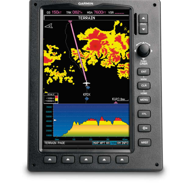
See your way clear of obstacles
Offering fast graphical rendering of map detail with database-driven terrain and U.S. obstacle alerting, the GDU 370 shows your aircraft’s position in relation to ground features, chart data, navaids, flight plan routings, and more. The colour-keyed terrain page offers both overhead and vertical profile views of potentially hazardous terrain along your route of flight. What’s more, by adding a Garmin GTX 330 Mode S transponder, your MFD can also display Traffic Information Service (TIS) alerts to help identify other aircraft in proximity to your position.
Electronic charts help streamline navigation
In addition to its high-resolution terrain map, similar in appearance to a VFR sectional chart, the GDU 370 comes with Garmin FliteCharts®¹ and SafeTaxi® pre-installed. The FliteCharts offer NACO-format IFR approach plates and terminal procedures for airports throughout the U.S. SafeTaxi gives you detailed taxiway diagrams and position information for over 850 U.S. airports. And there’s also AOPA Airport Directory data that offers detailed information on over 7,400 U.S. airports, along with airports of entry for Canada, Mexico and the Caribbean.
There’s more to come
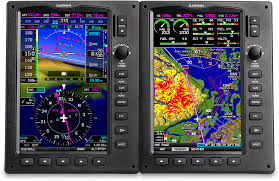
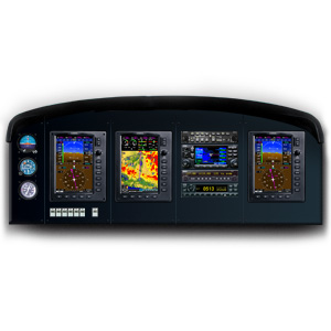
Future enhancements to the GDU 370 will enable it to accommodate not only MFD capability, but flight and engine instruments as well. Primary Flight Display (PFD) attitude/directional guidance with ADHRS Engine monitoring will be available in the second half of 2009. And up to three interlinked displays will be supported in a full Garmin G3X retrofit suite, with reversionary capability for added safety.
GDU 370: It’s today’s MFD sensation in light sport aviation
¹A single update of FliteCharts comes preloaded on the unit. FliteCharts will automatically disable when the data is over six (6) months out-of-date (six month period to commence when map is loaded in the factory). Each box will contain a certificate for one free current FliteCharts download. After the six month period, you must purchase a subscription for continuous FliteCharts chart availability.